Cooling and Greening Philadelphia: Changes in Roof Coating and Green Landcover Between 2010-2017
Introduction
Philadelphia has seen a significant amount of change over the past 10 years or so. As the real estate market recovered from the recession of 2008, we have experienced a lot of new construction coinciding with a very strong housing market. As of October 2016, total home sales were well above their historic average, and prices still rising (Gillen 2016). Coinciding with this increase in development has been a focus on preserving and protecting informal yet treasured parks and gardens whose ownership situation may leave them in jeopardy of being lost to new construction.
Another new force affecting the city in the past 10 years has been an increased focus on energy efficiency and greening the city. The Philadelphia Water Department’s Green City Clean Waters plan is a very ambitious effort to add rain gardens throughout the city and otherwise decrease the number of impervious surfaces in an effort to reduce the amount of pollution entering our waterways through the combined sewer system. Installation of rain gardens has been found to “dramatically reduce environmental impacts in every impact category” at much lower cost (Vineyard et al, 2015).
The installation of reflective roofing material is another trend that could contribute to a large quality of life improvement across the city. Replacing typical dark roofing material with a reflective coating can improve air quality, reduce energy use, and lower the overall carbon footprint (Bretz et al, 1997). One study measured the effects of adding a reflective roof coating to a large building in Austin Texas, and found that average summertime demand as reduced by 14%, at a cost savings of $490/month (Konopacki and Akbari, 2001). In concert with other efforts to increase the amount of green space and boost the energy efficiency of our older housing stock, there has hopefully been a noticeable impact in both the quality of life and Philadelphia’s impact on the surrounding environment.
With these two possibly competing forces, it is hard to estimate how much of an impact the various greening efforts have had. This analysis will use-high resolution satellite imagery to measure the effect that these forces have had on the amount of vegetative landcover and the amount of roofs with a reflective silver coating. We will be looking at a study area consisting of Center City Philadelphia, some of the surrounding neighborhoods in North and South Philadelphia, a small piece of West Philadelphia, and a bit of the waterfront in Camden, New Jersey.
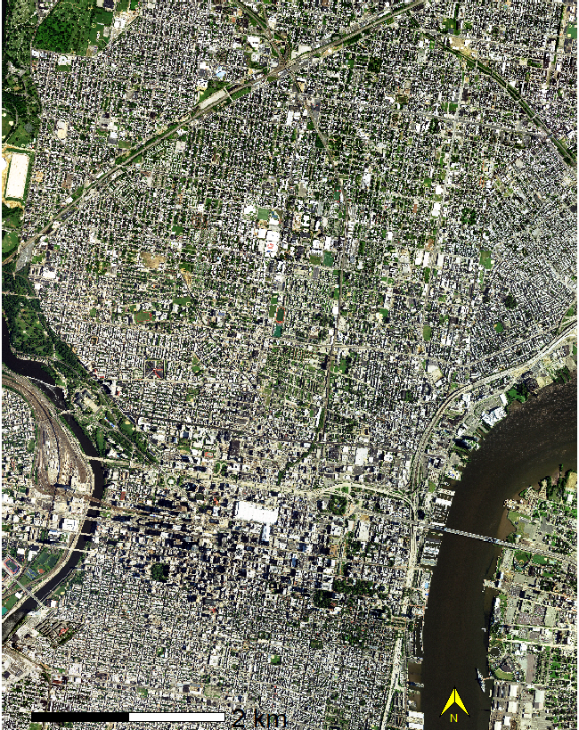 Figure 1: Study Area: NAIP imagery from August 9th, 2017
Methods
Table 1: Data Sources
| Date | NAIP Image Name | Source |
|---|---|---|
| 7/4/2010 | m_3907507_ne_18_1_20100704 | https://earthexplorer.usgs.gov/ |
| 8/9/2017 | m_3907507_ne_18_1_20170809 | https://earthexplorer.usgs.gov/ |
Figure 1 shows the study area, consisting of the full extent of a high-resolution aerial image from the USDA’s NAIP service in 2017. Because this image covers all of Center City and a large portion of North Philadelphia, it covers a very diverse spread of income and development levels, so it should hopefully provide for a view into a variety of neighborhoods.
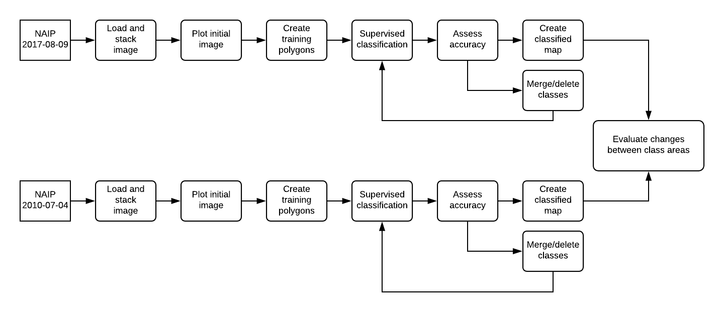 Figure 2: Final Analysis Methodology
Figure 2 shows our workflow for this analysis. We performed a supervised classification on two images taken in July 2010 and August 2017. This time period was influenced strongly by the availability of clear images with minimal clouds and haze. After loading the two images, we created a natural color plot and an RGB plot (R=4, G = 1, B = 2) to emphasize vegetation. The source for these images can be found in Table 1.
The next step in this process was drawing polygons to create 10 landcover classes to guide our supervised classification. Initially we created a minimum of 30 polygons for each class. This process was performed for each image. An attempt was made to distribute polygons throughout the study area to minimize bias caused by excessive clustering. There were a few problematic polygons which had to be deleted to enable classification to proceed, but most classes had enough polygons that this should not have caused a significant reduction in polygon count.
Next in this process was a few cycles of classification and evaluation. The supervised classification was run for each image using the appropriate set of polygons, and the accuracy matrix enabled us to evaluate the extent to which the classification engine was able to distinguish classes of polygons. The classes representing trees and grass were difficult to distinguish, due in part to the fact that our study area does not have many areas with dense tree cover where grass is not also present. Classes representing broken ground, and industrial areas were deleted, as they were very heterogeneous areas, and were therefore reducing accuracy without adding to the analysis.
Classes representing rail lines and asphalt were also deleted, as these were difficult to distingush from dark roofs, and making it difficult to compare data between images. The resulting classification has much higher accuracy, but the resulting image has all of the asphalt and rail lines included with the dark roof class. While not ideal, it should create a more consistent class, making comparisons between images easier. Furthermore, the reflective roof class had very low confusion through all of the classification runs, so an increase in that class should serve as a more reliable indicator of change than a decrease in dark roof cover.
After a few rounds of classification and accuracy assessment, the two final classified images were saved and quantified for evaluation.
Results
Table 2 details the changes in the five classes between 2010 and 2017. As I expected, the total area of the dark roof class decreased, and the white roof class increased. The total white roof area has more than doubled in this period, which is evident when comparing Figures 3 and 5. The total area of the green land cover class decreased by 6% between 2010 and 2017.
Figure 4 represents the user’s and producer’s accuracy for 2010. All of the classes had very high accuracy for this image. There were a few miscategorized pixels, but nothing substantial. Figure 6 is the accuracy assessment for the classification of the 2017 image. While not quite as good as that for 2010, the accuracy is very good for this assessment. There appears to be a small amount of confusion between the white roof and concrete classes, which may be responsible for artificially increasing the percent change in the white roof class. However, the magnitude of the change is significant enough that even with some introduced bias, there may still be valid results.
Table 2: Total area change for each class in Square Kilometers
| Class | 2010 (KM2) | 2017 (KM2) | % Change |
|---|---|---|---|
| Concrete | 6,656.51 | 10,703.35 | 60.80% |
| Dark Roof | 18,784.38 | 11,833.46 | -37.00% |
| Green | 12,152.69 | 11,389.43 | -6.28% |
| River | 5,087.26 | 3,503.20 | -31.14% |
| White Roof | 2,352.93 | 7,488.72 | 218.27% |
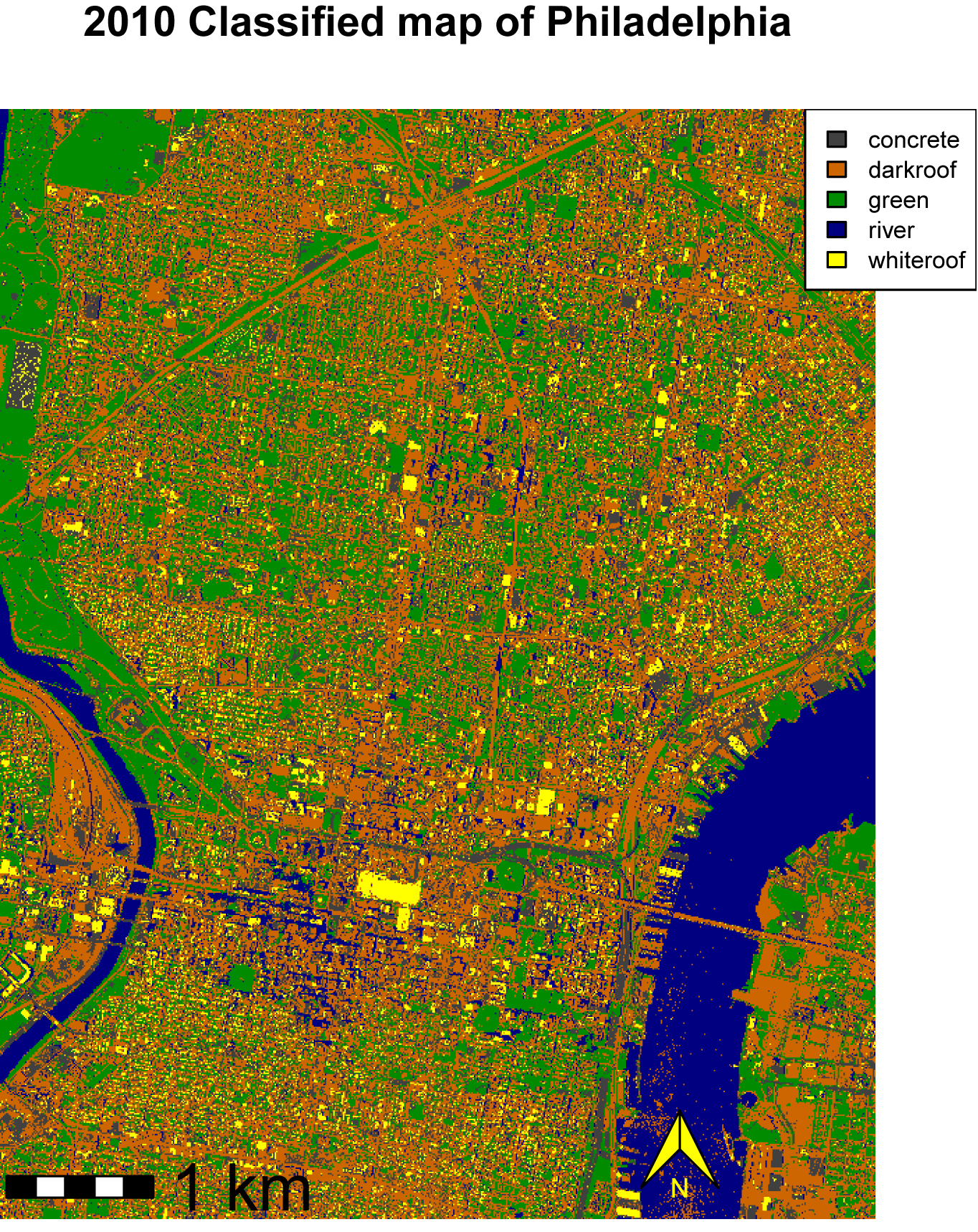 Figure 3: 2010 - Supervised Classification
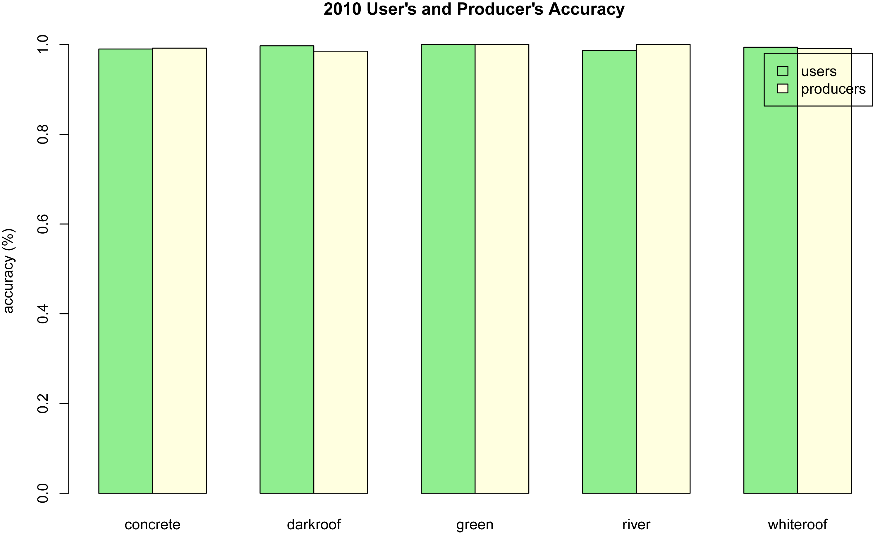 Figure 4: 2010 - Accuracy Assessment
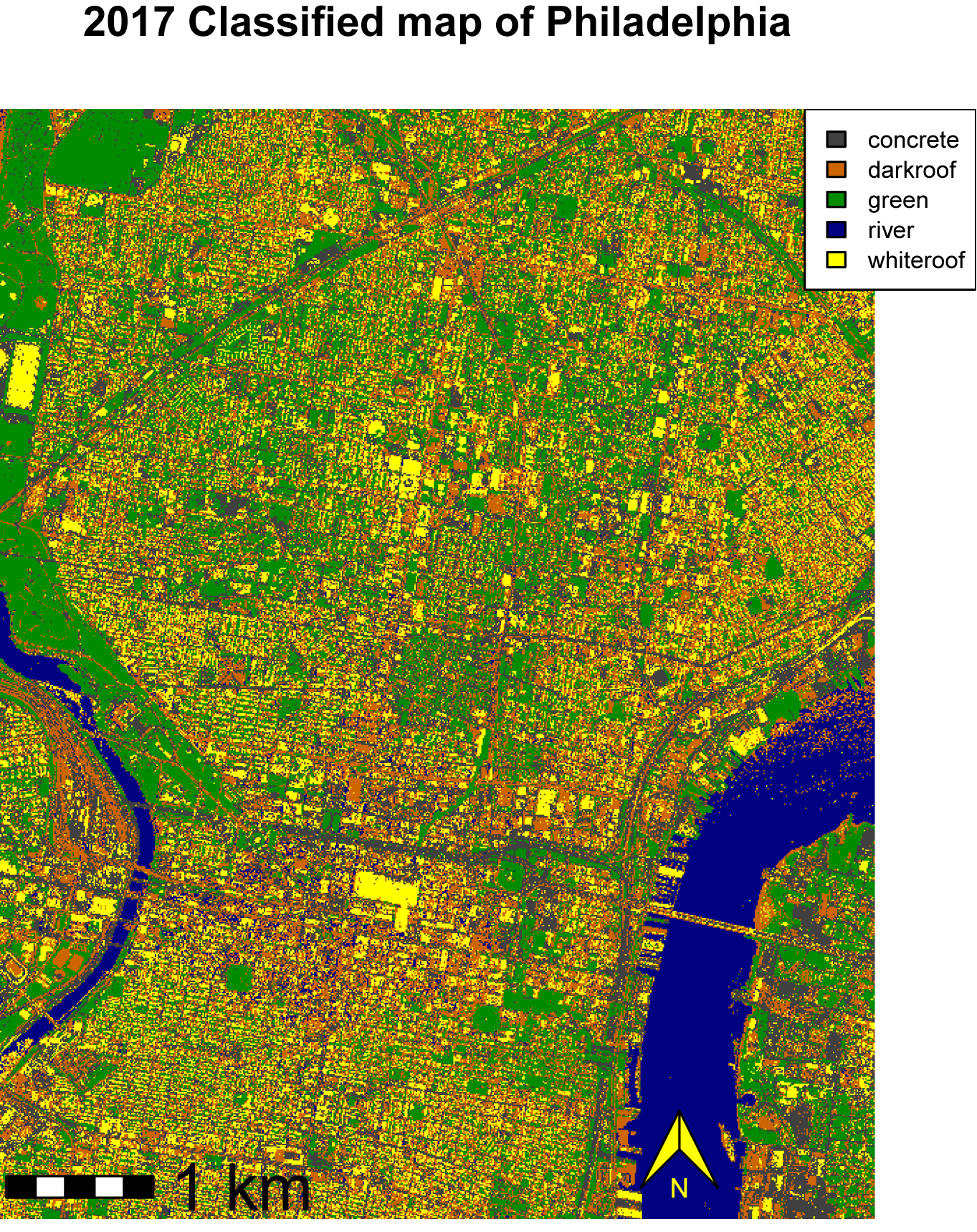 Figure 5: 2017 - Supervised Classification
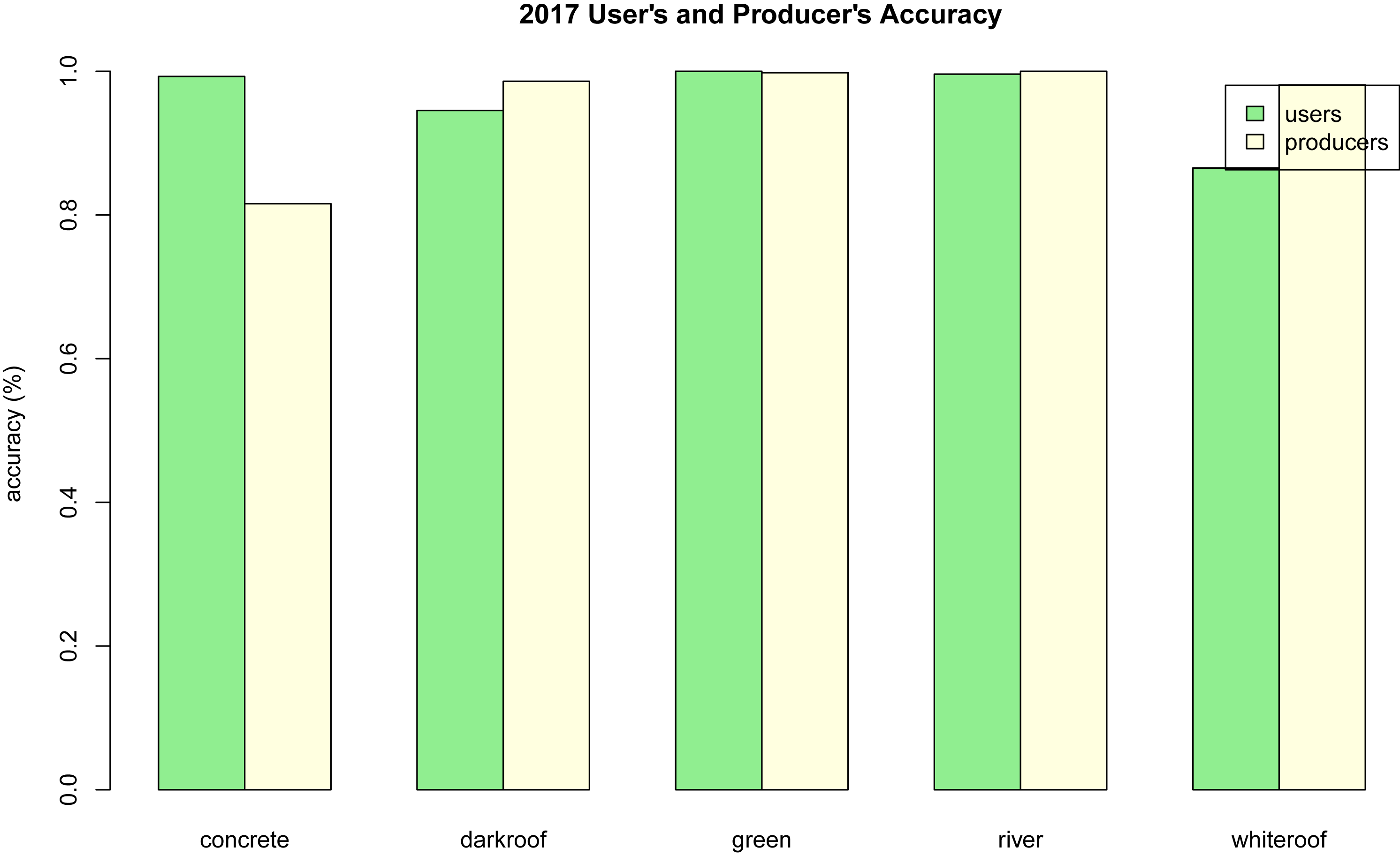 Figure 6: 2017 - Accuracy Assessment
Discussion and Conclusions
The 218% change in white roof cover between our two images was especially notable in lower-income areas. Neighborhoods with a higher average income such as Fitler Square and Fairmount already had a large amount of reflective roofing material in the 2010 image, while lower-income areas like large parts of North Philadelphia seem to have mostly dark roofs. This is especially notable on west Girard Avenue, where the sharp boundary between Fairmount and Brewerytown is demonstrated by a dramatic change in roof coating.
This could indicate that because wealthier areas may be able to keep up with roof replacement and maintenance more readily, the legacy dark roofs have been recoated or replaced much earlier. A combination of increased awareness towards energy efficiency and programs such as Philadelphia’s Energyworks Program (Matulka 2013) could have played a role in the large increase in citywide white roof cover in the 7 years covered by our study. A positive increase like this may support the idea that programs encouraging homeowners to add reflective coatings to their roofs may be effective. An analysis such as this could be used to justify further investment in these programs, and high-resolution imagery could be used to more precisely target underrepresented neighborhoods.
Between 2010 and 2017, there was a 6.28% decrease in green landcover. While there has been increasing attention paid towards rain gardens and other attempts to help depave parts of parking lots in schools and other municipal buildings, the total area is probably relatively small. During the same period, there have been a number of very large construction projects which would have removed grass covered vacant lots consisting of a large portion of a city block. Because of the probable difference in area between these two groups, a small decrease seems reasonable. To attempt to quantify the size of effect from these two competing forces, data on building permits and parcel records could be obtained from OpenDataPhilly. Adding this to the analysis could enable us to control for new construction and get more specific information on a possible increase in greenspaces.
References
Bretz, Sarah, Hashem Akbari, and Arthur Rosenfeld. “Practical issues for using solar-reflective materials to mitigate urban heat islands.” Atmospheric environment 32, no. 1 (1998): 95-101.
Gillen, Kevin. “Philadelphia Housing Report: Q3 2016.” https://drexel.edu/lindyinstitute/initiatives/reports/ (October 2016).
Konopacki, Steven J., and Hashem Akbari. “Measured energy savings and demand reduction from a reflective roof membrane on a large retail store in Austin.” (2001).
Matulka, Rebecca. “Philadelphia: The City of Energy Savings.” https://www.energy.gov/articles/philadelphia-city-energy-savings (February 2013).
Vineyard, Donald, Wesley W. Ingwersen, Troy R. Hawkins, Xiaobo Xue, Bayou Demeke, and William Shuster. “Comparing green and grey infrastructure using life cycle cost and environmental impact: a rain garden case study in Cincinnati, OH.” JAWRA Journal of the American Water Resources Association 51, no. 5 (2015): 1342-1360.

